Saturday, November 26, 2016

Getting Organized: Mind Map

Garth recommended and organizational tool called SimpleMind, a free download for the smart phone.  It's very easy to use and in minutes I created a neat "mind map" of our upcoming adventure:


I've basically no idea how to use this yet but just looking at it seems pretty reassuring and calming!  There are many useful functions that I should read about and these mind maps can be apparently shared and worked on by the whole team.  Very cool!

Garth Camac is on board!

Amazing news: our good Australian friend Garth Camac has joined a team as a supporter of flight, gear repair, and overall logistics.  I think our chances of success in the X-Alps have just doubled!


Garth is a competition pilot, XC record holder, and a globe-trotting adventurer who is likely to be more qualified to compete in the X-Alps than myself!  He has offered his assistance out of his own great kindness and generosity.  He will be in the Alps months ahead of the race and gather invaluable information about the route, first-hand.  Additionally, his past military experience as a platoon leader in the Iraq War will bring the team together and keep it organized.  It's going to be so much fun doing this together!  Thank you Garth, and welcome to the X-Alps 2017 Team Canada!

Full Condition

green: hike up,  blue: flight
As forecast, a strongish NE wind was blowing across the mountain today.  Eager to train some, I hiked up to the launch (31:08, new record with pack), not sure whether I would fly or just stash the gear at the launch for tomorrow and hike down.  Observing the wind for a while I saw it was pretty strong but relatively steady in both direction and strength, which is unusual for a NE wind breaking over the ridge.  So I decided to fly down.


At around 10°C, today was one of the first cold days of the season, and the light was accordingly stark and beautiful.  I managed to stay up against the Yahazu ridge for a total flight time of 11 minutes. My vario would not turn on, so I spent this short while listening to the changing sound of the wind while actively piloting my Delta 2, a good choice for a day like today.


Landing was a little tricky with the surface wind blowing all over the place, but with many of the fields fallow at this time of year, there was enough room for a low-precision landing.  (The crops visible are lettuce.)


In spite of the conditions I thought I was quite relaxed and had things under good control.  However, looking at my stats it was interesting to see two distinct peaks in my heart rate, both at around 130 bpm, one at takeoff, and one at landing!  I guess it was a little exciting after all!

Thursday, November 24, 2016

Weekend Marathon Trail Run

Calm and misty but not rainy weather was forecasted for last weekend, with no great flying possible, so we took time to revisit our favorite local mountain range, the Kyushu Central Mountains, about a 2 hour drive from our house.  Thrust up by the straight fault clearly visible on the right side of the image below, it's a 50 by 50 km area of extremely rugged mountains (Mt. Kunimi at 1738 m is the highest), with steep terrain everywhere, difficult to cross even by car, and to date, flown over by paraglider by yours truly only!  It's actually one of the remotest areas of all of Japan.

The tour: red course is mostly trail run (64 km, 3800m gain), yellow return course is mostly dirt road, 45 km, 1500m gain.
The 64km first day mostly follows the ridge tops after the initial climb up from the fault valley, eventually gaining 3800m, almost exactly the height of Mt. Fuji.  Leanne's course was a shorter variation at 37km and about 2000m gain, but she had to carry the pack with the camping gear.  Amazingly only one dirt road crosses the course, and it's almost entirely within virgin forest that's very rare in Japan; in fact the trail is very faint and difficult to follow, with a lot of deadfall and other obstacles. So in fact it was mostly not possible to run and I averaged only about 4.5 km/h in spite of giving it full effort.

Along the trail on Day 1.
We weren't sure we could actually make the whole course but we could communicate with ham radio transcievers (no cell coverage here!) and we arranged the logistics so that we would pass each other mid-way.  There were also various options for bailing out. But in fact, we both made our objectives, though our efforts stretched from dawn until 11:30pm.  (My day: 14h 30m, 5100 calories!)

The Shiiya Pass dirt road on the return trip.
After only chocolate bars and sausage for dinner and 6 hours of sleep, we began the slog back via the Shiiya Pass forest road, the only road that crosses this stretch of the range.  This time I carried the pack, which weighed about the same as a lightweight paragliding kit. 


These mountains are basically just heaps of earth and rubble, so landslides are extremely common and regularly render any road here impassable; only the Sisyphean efforts of hundreds of Japanese construction companies keep them from completely disappearing.  This slide was steep, fresh and loose, and actually pretty hazardous to cross even on foot.

Fearing more slides ahead we shortcut a section of the road, down a very steep ridge and eventually crossing a small clear river via a landslide control dam.  The freezing cold water felt so great for the feet, I had to go wading some more!


Finally back in civilization, the last 15 km to the car were on paved roads.  In spite of the previous day, we were able to walk an average of 5.5 km/h today, and were not really tired, just our feet hurt.  At the end of 110 km of trekking in 2 days, we relaxed at a local hot spring.


Whereas I only got one blister, Leanne's feet were pretty trashed.  This trip has shown us many lessons which will be valuable for the X-Alps.  For instance, it would have been great to have had a needle along for blister control - presumably, if treated early, they won't blow up so big!  Also, we should try those vaseline-like creams to see if they work.  

A more subtle lesson involved the power of concentration.  I find it very meditative to run or walk long distances, and so I don't notice things that might be important.  As an exercise, I tried to measure the time between kilometer markers on the forest road, but often missed the small signposts even though the GPS was counting the distance very nicely for me.  Zoned out, I would look at the screen only to see I'd already walked 1.5 km from the previous marker!  Of course it didn't matter today, but during the X-Alps paying close attention to accurate navigation is very important and besides, I'm sure there will be many other logistical things on my mind.  I must train to be able to walk and think at the same time!

26 km shuffle

This entry is a few days delayed due to IP problems...sorry.  Anyway, this was our training on Nov. 17th.

26 km running course (all pavement, with 280m elevation gain), Shinwa Town, Amakusa.
Strong north winds again made flying out of the question again on this otherwise nice day. Determined to practice the 'ultra-marathon shuffle', we set out on this longish course.


In the end we were able to run the entire loop with ease, at a controlled pace of 7:15 per kilometer (we were actually aiming for 7:30 or 8 km/h).  The whole run took 3h 09m, and apparently burned 1300 calories.


Much of the course is along the seaside, with pleasant views across the Hachiman Straits along the quiet, coastal road.

In the end, no sore muscles, no sore joints or feet.  Is it possible to run all day like this carrying a 10 kg backpack too?

Thursday, November 17, 2016

Leeside Flush with the Poison X-Alps

Flight and Slogs
An very low inversion and a moderate NE wind conspired to make Kuratake unsoarable (at least for me).  The inversion was forecasted to be at about 500m, which seemed to agree with reality, since from the TO (455m) the distant peaks of the Kyushu Central Mountains were peeking out above the haze, and even the kites did not seem to be able to top out Mt. Kuratake (682m).  And so the NE wind poured almost unimpeded over the shoulder of the mountain, with worrisome gusts and only occasional breaks. I had a work commitment in the morning and what with the hike-up with gear (32 min) , I did not get to the TO until 11:45.

Wind data for the day.  Vertical red line shows takeoff time.
I hopefully waited for things to calm down a bit, and after waiting out a longish period of downslope wind, ended up taking off at 12:53.  I hit a nice, safe little window but in retrospect perhaps around 12:10 would have resulted in a little more lift.  At that time, I was worried about the gusts (pink line), flying the new glider in rotor, and the fact that I was on my own today, with Leanne too having to work earlier than usual.

Heading to the beach!
I found some weak lift in the offing but it did not last long, so I went downwind looking for more but the lower I got the stronger the wind became, so there were no more thermals.  On the other hand it was not as rough as I expected, and  I suffered only one minor wingtip collapse.  I let the wind carry me to the beach where I misjudged the approach slightly and got caught in the sink and offshore blow behind the small hill, landing only meters from the shoreline and making a bit of a crater in the soft sand, as the sink continued unabated all the way to the ground.  A left-turning approach, where there is no hill in the way and therefore more wind but no sink, would have been smarter.  I guess I got a little greedy surfing the small wave upwind of the hill together with the local kites.


Wednesday, November 16, 2016

More Training and Research

Training runs on Nov. 14 and 15
These two days were both unflyable, with light rain falling on all of Kyushu on Monday, and strong NW wind on Tuesday, which is also a work day for me.  After sitting behind our computers most of the day Monday working on sponsorship materials, Leanne and I decided to go for a run in the evening, and it was quite enjoyable though we got a little wet and by a small error we ended up running the loop (otherwise one of our favorite MTB trails) in the opposite directions, meeting up again in the deep mountain just as darkness was gathering.


That night I did some research about training, which somehow led me to Pheidippides and ultra-marathons.  Watching some YouTube about the 900 km Sydney-Melbourne race as well as the Self-Transcendence 3100 mile race in New York led to a lot of surprising new information and many things to think about. Thus inspired, on Tuesday we tried to perfect the distinctive 'ultra-marathoner's shuffle' on the pavement section of the run, finding out it worked quite well and it was quite easy to maintain 8 km/h with hardly more impact and only a little bit more effort than walking at 6 km/h.

Monday, November 14, 2016

More Poison X-Alps Test Flying!


Advection of warm air from the south today made for some very weak conditions, especially low down on the mountain, whose surface had cooled over the past week, but after a lot of effort Leanne and I were both able to speck out and go to cloudbase.

After takeoff, all the usual places failed to give sufficient lift; I eventually found a very weak release point in an unusual spot almost at the end of the ridge.
Leanne was flying her Tala very light without any ballast, whereas I was just a kilo or two below the max. all-up weight on the Poison X-Alps.  The increased airspeed was very obvious, but today this was not going to be an advantage for me! I think it was thanks to the Poison's sensitivity and agility that I was able to delicately center the small, weak thermals and ride to success today.  Of course, its glide performance musn't be too shabby either!  In any case, today's two other flyers could not top out, and neither could I earlier with the tandem.  Another few score points for the Poison X-Alps!


Unlike yesterday I got enough extra height to do some more testing.  The air was once again not rough enough to be interesting so I did some induced collapses.  Here, I yanked down hard on the entire right A-riser.  And: no problem!  Holding down the riser I could still fly straight with less than a half of the wing inflated, although it was hard to avoid pilot-induced bank oscillations.  Upon releasing the riser, the canopy sorted itself out completely and automatically in less than a couple of seconds.  In several trials here was no tendency for the lines to get stuck on the leading edge plastic rods near the wingtips and causing a cravatte, a common tendency these days displayed by a few other high-aspect gliders I have flown.  I find this cravatting kind of scary because of incidents where after a full frontal, the cravatte caused a tendency to enter a spiral and/or SAT as the glider tried to recover.  On a couple of occasions I had to full-stall the glider to get out of this, but that's an option only if you have a lot of height.  So, the Poison's behavior in this respect is a big relief of an important safety concern I have.


I had just enough disposable altitude left to do a few wingovers.  It's always fun to see one's shadow dart across the canopy!  As expected, already after the first swing the fast and agile glider wound up fully into very energetic wingovers.  What with the rapid, rotations and sudden G-forces, I didn't dare to rotate the canopy any closer to the horizontal.  No surprises here!


Today, there was a "Walk Rally" event at Kuratake, with over 200 hikers climbing the mountain by either the paved road or the hiking trails we help maintain.  For the first time in years the weather cooperated enough for us to fly and give the hikers a bit of a show!


In the late afternoon, a short burst of thermal activity near the inversion created even some thermal clouds!  Leanne and I spent over an hour playing around the cloud edges at around 1300m.

Image showing Rick's flightpath (blue) and the return walk (green).
Lift began shutting down around 3pm and as it was our day off work, we both decided to fly to Sumoto and hike the 11km or so back up the mountain to retrieve the car.  We scarcely get a chance to do this together, so it was pretty special!  We first went to Domeizan where Leanne practiced for the first time finding the elusive thermal that makes the flight to Hondo possible.  Today the timing was much too late but we did find the typically complex wind conditions and rode a few incipient thermals before having to turn toward the LZ.  In spite of losing more height on the glide in, Leanne found the better thermal and was able to stay at Domeizan for a couple more minutes.  Well done!

Some excited little girls greet Leanne as she lands in Sumoto.  Now, pack up and hike up!

Tandem Fund Raising・タンデムでXアルプスの募金


I decided to offer tandem rides in exchange for donations to my X-Alps fund.  Today, Mary-Ellen, an assistant English teacher in Amakusa, was the first to take me up on this offer.  For those interested, please get in touch!


Xアルプスのため、タンデムで募金しよう、とのアイディアがありました。日曜日、天草のALTのメアリーさんが、最初の提供者になりました。興味のある方、是非ご連絡してください!


I've flown with her before, so she already knew the drill, making the takeoff  easy in spite of very light and variable winds.


メアリーさんはタンデムの経験があったので、風が弱かったのに、テイクオフがうまくできました。


We spent a very enjoyable time in the air.  She likes paragliding and is thinking about taking flying lessons herself.  Mary-Ellen, I'm glad you had a good time, and thank you for supporting me and my X-Alps project!


コンディションは渋かったが、楽しい空中のひと時を過ごしました。メアリーさんはパラグライダーを習いたくなりました。頑張ってください!Xアルプスの支援、どうも有難うがございます!

Sunday, November 13, 2016

Test Flying the Skywalk Poison X-Alps!

Trail to the Kuratake Takeoff
The day started with a trail run to the Kuratake TO, and I scored a new record of 22 minutes 50 seconds.  Getting stronger every day!  The trail is about 1.8 km long and has a vertical gain of 410 meters.  It is therefore quite steep and particularly the second half has an average grade of about 30%, so it's not really a 'run', but rather an awkward struggle uphill.  This trail also forms a grueling finish to the trail run section of the Amaxa X-Athlon, a multi-sport race we organize in Kuratake every summer.


But the day's main excitement was test-flying the Skywalk Poison X-Alps glider for the first time!  I used to fly a Poison 3 a few years ago and really liked it, mostly because it was fast and very agile for a glider with such a high aspect ratio.  So when Canadian pilot Alex Raymont recommended the Poison X-Alps, saying it packs up smaller than the Ozone LM6, I contacted Tetsuya Sato, the Japanese Skywalk distributor and a good friend. He immediately got on the case and sent me this XS-sized test glider (thank you!).  The glider was mailed to a flyer friend who runs a drug store, and when he handed me the package, I thought he was pulling my leg and giving me a box of toilet paper instead!  At about 4 kg, it's the lightest glider I've ever flown - by far.

And in the air too, the Poison X-Alps did not disappoint: just like its predecessor it is very quick and nimble!  Also, the brakes feel smooth and very responsive, and there is excellent feedback to the pilot both independently through each riser and through the brake controls.  Just as advertised, brake travel is short but resistance increases smoothly and distinctly, so there is absolutely no danger in accidentally stalling; at least not for an experienced pilot who can feel his brakes.  Anyhow I much prefer short brake travel because it saves on the effort of controlling the glider--I don't want to be waving my arms all over the place and even just holding inside brake far down during thermalling does result in arm fatigue over a long flight.


As predicted, today was a high-pressure day with a very strong inversion at about 900m, which one could punch through, if only briefly, right above the summit of Kuratake and get a peak at the distant Mt. Unzen volcano, whose 1483m summit was poking out well above the inversion.  This also meant that in spite of the weak November sun, the squeezed-down boundary layer was roiling and seething, making for some bumpy thermals, though nothing that required any intense active piloting.


At this level of turbulence, the Poison X-Alps performed great, riding out the bumps nicely even when I half-neglected the brakes.  Leanne and I rode out several tight thermals close together from low down on the mountain, and with the Poison's agility it was easy to direct it exactly where I wanted it to go in the very uneven cores.  I also got the feeling that the inner wingtip did dig into the lift more than most gliders, helpfully self-steering itself into the thermal, which, I recalled, the old Poison 3 used to do as well.  I feel that the Ozone M4, M6, and Delta 2, which I fly a lot, are more or less neutral here, whereas some other gliders I have actually tend to turn away from lift, making it quite a bit of effort for the pilot to stay near the core.  The Poison is also distinctly more agile than the Ozone Mantras, and nearly as nimble as the Delta 2, which I think stands out among C-graded gliders for its maneuverability (intermediate-level pilots seldom fly it well).   How does Skywalk make its high-aspect gliders so nimble, and thermal-seeking to boot, is a secret I would like to know.


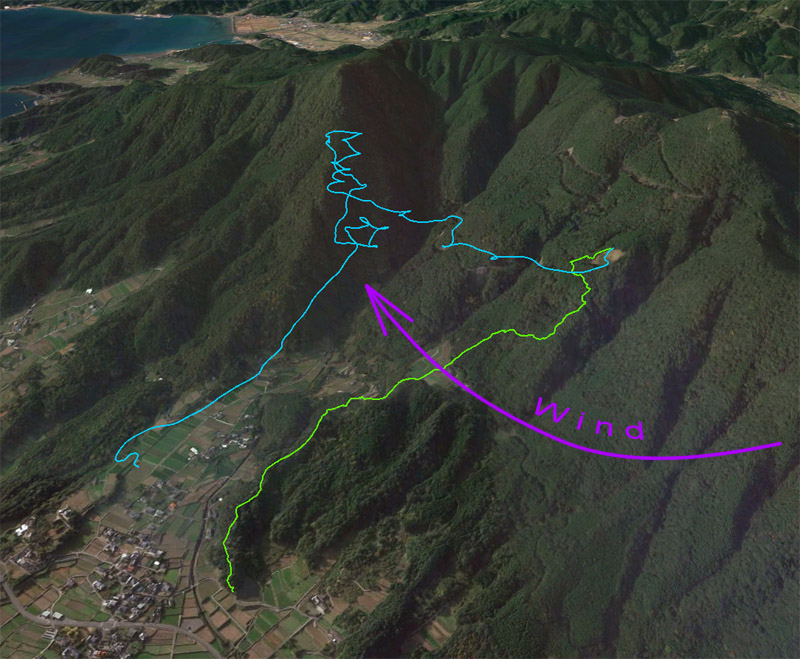
Alas, all too soon it was time to turn west and begin my (nearly) daily aerial commute to work.  Today, with the low ceiling, I did not expect to make it past Sumoto (the large valley about half-way), but with SSW wind aloft, the Domeizan thermal was easy to find and took me back up nearly to the inversion.  Normally less than 1000m is not enough to continue westward over the powerline-infested hills but expecting some more squeezed-boundary-layer thermals, I pressed on.  Incidentally, I was flying the XS-size glider (rated to 90kg max) with an all-up weight of 88.5 kg, so glides were rather brisk, and I found myself doing over 40 km/h ground-speed even against the wind, where I would expect low 30's on my over-size (ML) M6.  The feeling of speed was quite refreshing, and in spite of this L/D was still good and thermalling with Leanne, who is very light on her BGD Tala (usually flying 5 kg ballast but not today), I did not notice any disadvantage.  Well, anyhow, it's a good sign that I made it all the way to Hondo on my very first flight with the Poison X-Alps.  The expected thermals were there, and helped a little, for sure!


Coming up just short of my usual LZ (the large open area on the right), I aimed for the tidal flats which were in places nice and dry.  (Had it not been low tide, I would have had to land a few km back.)  Almost always the wind in Hondo is onshore from the NE, even when it's southerly in Kuratake, so the last section is more or less upwind and one needs to leave some margin flying over the sea and urbanization, if the tide is in.


The light fabric of the glider floated down to the gravel like gossamer.  I like this glider very much!  But I have to fly it in some rough conditions, to see how it behaves compared to the M6, which I am very used to, before I decide whether to fly it in the X-Alps.  Other makers have been approaching me as well, so it's going to be an interesting choice!  In a way I am lucky I am not professionally sponsored, because I can decide what I will fly based on what I like and what is good and safe for me.  I am looking forward to this process quite a bit.  Now, for further testing, I'm hoping for some rough conditions during the two most benign months of the year here in Japan!


Friday, November 11, 2016

Ryutozan Walk


A comfortable 16km speed walk today, on paved roads only, along the scenic ridge to Ryutozan, a mountain with one of the best views in Amakusa.


From the top, one can see Amakusa's seas and mountains in equal measure. Although the mountain is not so high, the views are outstanding. A skillful paraglider pilot can also fly from here!  But in today's gusty northwest winds it wouldn't have been very safe.


Looking west across the rugged mountainous interior of Shimoshima Island, Amakusa's largest. A flight along these ridges to the island's southern end is one of my as-yet unrealized projects.

Thursday, November 10, 2016

Just a Run

My usual 8 km run course on the outskirts of Hondo.
Light rain today from morning on, so just a quick run today, then sponshorship planning, etc.  All kinds of requests are pouring in so we have to act on them soon.  Also, a glider arrived in the mail today, for me to try!  Can't wait to fly it; probably the next chance is Saturday.

As for the run, with fatigue accumulated in my legs from a solid week of hard exercise, I did not expect anything great, but my Garmin Fenix3HR watch pushed me once again to exceed my expectations with its great 'Race an Activity' feature where you virtually race your own (or someone else's) previous performance, and the watch gives you a real-time progress data.  It's amazing how well this psychology works, since I've exceeded my previous performance every time, and by quite a lot!

Here's a chart of some of my runs on this course, using data collected by the Fenix3:

Date    Race Time  Avg. Heart Rate  Avg. Cadence  Avg. Stride Length  Calories
11/10  39:17           148                     178                   1.14                         493
10/29  39:38           162                     174                   1.16                         552
09/10  41:10           150                     172                   1.13                         491
08/24  44:35           153                     165                   1.09                         566

If we trust the data is accurate, we must conclude that my body is quickly becoming more efficient, and fatigue has little role in spite of the amount of exercise I am piling on.  For example the 10/29 run had my heart rate absolutely maxed out, whereas this time a much more comfortable heart rate nevertheless resulted in a faster run, a faster cadence, and yet fewer calories spent. Actually, it's quite comparable to the 9/10 run except for the nearly 2 minutes of time saved!

50km MTB Training

Training for Nov. 9th.  Length 48km, elevation gain 1075m.
Strong northeast winds today in the wake of a cold front; much too windy to fly leeside, or even front side, so it was time for another training tour.

This MTB tour crosses Amakusa Shimo-shima Island from my house in Hondo, Amakusa's main town, through rugged mountains toward the west coast, passing by the Reihoku thermal power plant before again plunging into the mountains to cross back to Hondo along a different route.  Most of the course is narrow paved mountain roads but dirt roads and a single-track section are also there.  The scenery is good throughout: views from the mountain ridges, sea-coast, and scenic rural landscapes in the valleys abound.

I tried to power up the hills with my heart rate at about 80% of max and my muscles aching with lactic acid, maintaining climb rates of 16-20 vertical meters per minute.  On the rest of the course I took it a little easier, enjoying the scenery.  Still, my average speed was about 19 km/h, not bad when all that climbing is factored in.  While my muscles are sore tonight, the soles of my feet are quite relieved to get a day's rest from the unrelenting pounding they have received with all the walking and running during the past week.

注目の投稿

What is in this blog?

Hi!  This will be a blog about my experience in preparing for and competing in the Red Bull X-Alps, IMHO, the coolest race in the world!  Wi...